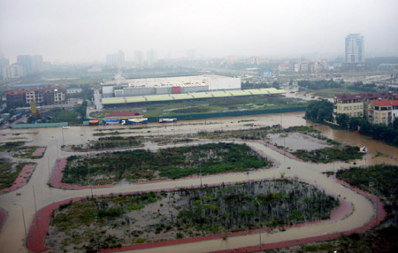
Hanoi authorities and urban planners often “ignore the infrastructure factor when approving the city’s urban projects” and floods due to heavy rains are the consequence.
The argument was put forward by Ngo Trung Hai, deputy head of the Institute for Urban and Rural Zoning under the Ministry of Construction.
How do you evaluate Hanoi’s urban planning given the recent flooding?
 Ngo Trung Hai (Photo by Ngoc Nam): The floods show the worst flaw in the city’s urban planning and the heavy price it has to pay.
According to a plan approved in 1998, Hanoi was supposed to prevent flooding with around 40 lakes – more than 10 percent of the city’s area – and four rivers running into the Red River, but the city’s development has meant that those are not enough. Meanwhile the city’s drains are surely only 40 to 50 percent as big as those designed in another plan to improve the city’s drainage system. It’s easy to understand how roads can turn into rivers.
But even according to the design, Hanoi’s drains can only handle rainfall of 170 millimeters a day or less. How can it be blamed for the flooding?
– Of course the drains were not designed for the maximum rainfall, because it would be very costly. But in case of such heavy rains, the city should have emergency drainage systems or measures to control the water flow. For example, instead of waiting for the water to flow outhward into Yen So Lake, the city authorities should save time by driving it northward into the Red River. Hanoi, just like most of our cities, is unable to do that.
The recent flooding hit the city’s new construction works heavily while the ancient ones and those built by the French many years ago are untouched, what’re the reasons?
– There’re two reasons. First, the old ones were built on high areas. Second, the new urban areas have very low-quality infrastructure. In many countries developers aren’t allowed to sell houses when the infrastructure in that area is unfinished. In our country, they are, and the residents have to suffer afterward. The National Conference Center was also hit because it’s too low and should be raised by about one meter or so.
How important is infrastructure to urban planning?
 – It should be the primary concern in urban planning but actually it’s not. Recently construction inspectors have found many urban projects lack detailed planning on infrastructure but they are still approved by Hanoi authorities. It’s against construction laws.
What do you think Hanoi should do to prevent flooding?
– It should enlarge lakes, canals and small rivers. It may even have to remove some slums to do this. Recently in Seoul a river was dug to replace a highway while the Netherlands is going to destroy three roads in Amsterdam to give space to waterways.
According to the Construction Ministry, Hanoi has been expanded to have more land for urban development. Do you think the new Hanoi can avoid floods?
– The Institute for Urban and Rural Zoning and international construction experts have suggested that the new urban areas should reclaim land from rivers or lakes. Then the new areas will not be flooded.
By Tuyet Nhung


